


Sentier de Mallevrière

ja.13061965
User
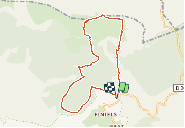

Length
9.4 km

Max alt
1699 m

Uphill gradient
387 m
Km-Effort
14.6 km

Min alt
1314 m

Downhill gradient
387 m
Boucle
Yes
Creation date :
2020-06-25 08:19:38.084
Updated on :
2020-06-25 16:31:46.721
5h15
Difficulty : Easy

FREE GPS app for hiking
 SityTrail
IGN / Geographical institutes
SityTrail Plus
The world is yours!
About
Trail Walking of 9.4 km to be discovered at Occitania, Lozère, Pont de Montvert - Sud Mont Lozère. This trail is proposed by ja.13061965.
Description
Montée très agréable en sous bois. Mont Lozère incontournable. Descente tranquille sur GR et DFCI. Temps de parcours avec pique nique et flâneries...
Positioning
Country:
France
Region :
Occitania
Department/Province :
Lozère
Municipality :
Pont de Montvert - Sud Mont Lozère
Location:
Le Pont-de-Montvert
Start:(Dec)
Start:(UTM)
559683 ; 4917397 (31T) N.
Comments